Supervisor:
History and Theory of Architecture and Art
2005
The history of the city of Rethymno presumably began during the 3rd century BC, when the first inhabitants settled on the hill of Paleokastro. This area was most likely deserted during the 5th century AD, while first signs of life became apparent again during the Second Byzantine period. When the Venetians conquered Crete in 1229, Rethymno was referred to as a small settlement, while in 1307 it had already developed into the third largest city on the island. The initial centre existed around the harbour, but shortly the city expanded beyond the Byzantine wall. In 1538 the city wall was built, while in 1588 the council decided to transfer the city to the area of the Fortezza, a plan which was never realized. In 1669 the Turks seized the city of Rethymno, whereupon several open spaces were built up. After the liberation and as soon as the city became autonomous numerous large projects aiming at the restoration of the city were completed.
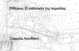
The expansion of the beach was one of the few interventions in the urban network, which were accomplished during the Venetian occupation. While the rest of the city combines both Venetian and Turkish elements, there cannot be any confusion in this area. For this specific reason this area has been chosen, since the period of the Turkish occupation has not been examined. This subject has been chosen with the ultimate aim to register the situation of today, and to reveal the characteristic elements of this area. Initially the area included three oblong blocks of buildings, while at the beginning of the 20th century three more vertical roads were built. Since there are no written records regarding the period of the Turkish occupation, this research had to comply with very few plans dating back to this period, the reports of travelers, the documents of the Ecclesiastical Court of Rethymno (only documents dating back to the 16th and 17th century have been preserved) and finally the records of the Land Registry of Rethymno, in order to determine the exact date of construction of this area. The above-mentioned evidence led us to the conclusion that the expansion was accomplished between 1754 and 1834.The outline of the area as it appears today was first recorded in the topographical plan drawn up in 1850 by G. Wilkison. The area was inhabited for its economical rather than ethnological characteristics. Its residents belonged to the higher stratum of society, and the central road became the most commercial street of the town.
The buildings in the expanded area show similar characteristics, while the building blocks are separated into properties of equal width. Thus it can be assumed that the area was either built up based on organized planning or that due to modern ways of construction a single type of building prevailed. The ground floors were designed for commercial use, while the upper floor provided the residence consisting of two large rooms and one or two sections of subordinate use, which were designed around a corridor, and at least one fanlight was essential for lighting.
On old photographs of the area 15 wooden balconies projecting from the façade of the buildings as well as two wooden walls can be distinguished, a large part of which has been destroyed. Today we can distinguish buildings of various architectural styles such as the eclectic and the neoclassical style etc. However, the area’s main characteristics are the buildings, which were constructed initially, and to which another floor was added later.
Further to the research of the Aristotelian University of Thessalonicawooden pergolas were built at the seafront, which in fact created a new block of buildings, since the initial constructions suffered modification.