Eretria, is a small, seaside town of about 3.156 residents (according to the 2011 population census), which is situated in a distance of 21 Km southeast of Chalkis, in central Euboea. Despite the fact that during ancient times, Eretria was one of the most important political and commercial city-centres of Greece, her recent history begins in 1824, soon after the Greek Revolution of 1821, when refugees from the island of Psara, which has been destroyed earlier by the Ottomans, settled in the area. The modern town was built on top of the remains of the ancient city and was titled as “Nea Psara” until 1960.
Although the city has rapidly developed, particularlyin the field of tourism, during the 20th century and its population has increased since the late ‘90s, there hasn’t been any solution on the issue of the several non-realized urban plans and the trespassing of the archaeological sites continues. The intense construction activity that takes place throughout the municipality of Eretria and its borders, as well as the lack of a design project, that could suggest a unification or a well studied projection of the most important archaeological discoveries, cause an enormous difficulty to the archaeological research and its progress.
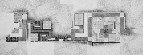
The subject of this thesis is an imaginary design project that gives the potential to think and organize a network of movement flows and public spaces along the vertical axis of the existing city plan, in order to unify the archaeological sites, situated on both sides of the axis. The design also creates a link, between the two natural boundaries of Eretria, the north end of the town, where the ancient Acropolis is placed, the mount Olympus and the south end, where the modern port is formed. This particular area is a design subject and an object of interest since 1834, when Cleanthes and Schaubertpresented their neoclassical urban plan, whose guiding lines are still visible nowadays. More recently, within the pages of a study published by the archaeologist Clemens Krause in 1977, the area is characterized as a clearly defined archaeological strictly protected zone, where any construction activity is prohibited.
The design process utilizes several ancient Greek patterns, which can be seen in ancient Greek art and architecture. The usage of these forms as fundamental components of the design, aims to criticize the modern architecture of the area that simply reproduces and uses them so it can be able to bring to the surface the cultural heritage that lies in its fountains. This design approach brings her purpose to a failure, downgrading, among other things, the city’s neoclassical background.
The structures and guiding lines resulting from the patterns are scattered as re-discovered fragments throughout the vertical axis, surrounding from north to south important archeological sites, such as the House of the Mosaics,the Sanctuary of Apollo Daphnephoros, the Tholos in the Agora, the Baths and re-forming the central seaside square of Eretria.