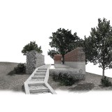
The settlement of Ano Kerasia is located on the western slopes of northern Pelion and was abandoned by its inhabitants when it was completely destroyed by German occupation forces in 1944. Apart from minimal interventions, most of the buildings of the settlement are kept in ruins. From 2015 the settlement of Ano Kerassia is characterized as a historical site and is protected by Ministerial Decree of the Ministry of Culture and Sports. In the context of the diploma thesis, a selected number of ruins is treated with a common vocabulary regarding the composition of volumes and the use of materials. The interventions in the settlement acquire a point and a linear character, they trace the historical memory of the place and penetrate into the natural landscape.In five different ruins, representative of the different conservation statuses encountered in the settlement, solid concrete volumes that maintain the initial geometry imposed by the building footprint and end up on sloping roof surfaces. Thus, the four new shells become hikers' shelters and one keeps the historical archives of Ano Kerasia.A new path is designed to connect four ruins that are significant to the history of the settlement, ignoring for the most part the existing paths. “Koukeiko”, the English Mission, the Commissariat, and the School were landmarks and reference points during the Resistance and the years before German occupation.As in the case of shelters, the historic path is made up of solid concrete blocks flanking surfaces with verticallyplaced stones. Interventions in the four landmarks are done with the materials selected for the rest of the ruins, but in a weaker way since it is intended to stop the wear and to remind.


